
Each year the Arizona Center for Rural Health (AzCRH) creates a rural and safety net healthcare facilities map. It is published in the Annual Report, as stand-alone PDF, and as an interactive map on the AzCRH ArcGIS Hub page.
The map's purpose is to inform health system stakeholders about the location and distribution of these essential healthcare facilities. These maps include only a subset of health facilities in Arizona as described below.
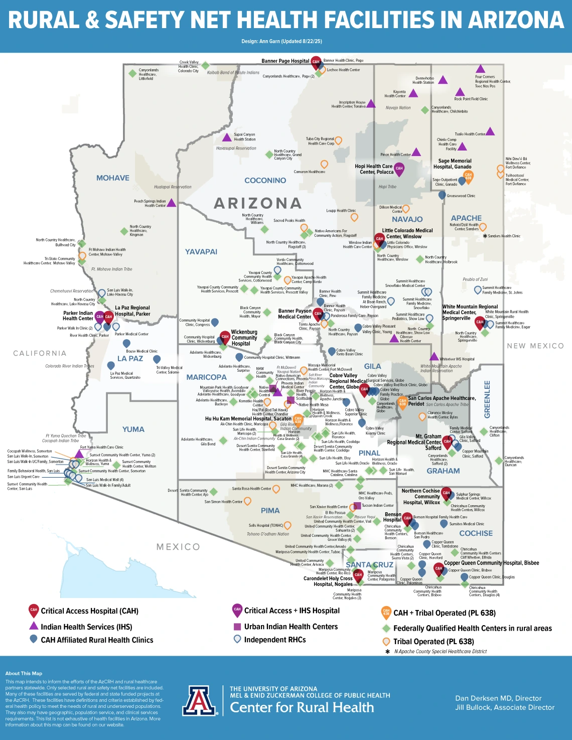
What facilities are included?
The AzCRH definition of rural and safety net facility is based on facility types. These facility types have specific definitions and criteria established by federal health policy. These facilities often have specific geographic, population service, and clinical services requirements they must meet. The facility types included in this map have been created by Congress to meet the needs of rural and underserved populations. Many of these facilities are served by federal and state funded projects at the AzCRH. This list is not exhaustive of health facilities in Arizona. It is a focused list aimed to inform the efforts of the AzCRH and rural health and healthcare partners statewide.
Critical Access Hospitals: A Critical Access Hospital is a rural acute care hospital with 24/7 emergency services and no more than 25 inpatient beds. Critical Access Hospitals must also be located more than a 35-mile drive from any other hospital or CAH (in mountainous terrain or in areas with only secondary roads available, the mileage criterion is 15 miles) and not exceed a ninety-six (96) hour patient length of stay.
Rural Health Clinics: Outpatient healthcare clinics that must provide primary care and basic laboratory services. RHCs must be in rural, underserved areas.
Federally Qualified Health Centers and Look-alikes: Outpatient healthcare clinics that provide comprehensive and coordinated care regardless of patients' ability to pay.
Indian Health Service Hospitals and Clinics: IHS is the federal agency responsible for providing federal health services for American Indian and/or Alaska Native people. The IHS directly maintains its hospitals and clinics. There are three IHS areas providing services to eligible American Indians in Arizona: the Navajo Area IHS, Phoenix Area IHS, and the Tucson Area IHS.
Tribally Operated or Tribal P.L. 638 Hospitals and Clinics: Tribal contract or compact health centers are operated by tribes instead of the IHS.
Other Tribal: This groups includes mostly Urban Indian Health Organizations. These organizations provide different types of services and levels of care to the American Indian and Alaska Native population who live in urban areas or do not live on or near a reservation. Organizations can include health centers, health stations, behavioral health, dental, and substance use treatment locations.
We start with last year's list of safety net facilities that is stored in the AzCRH workforce project data warehouse. Then we check other state (e.g., ADHS licensed providers list, the state Medicaid program) and federal sources (e.g., Indian Health Service, Centers for Medicare and Medicaid Services) to verify this list and check for additional facilities that may not be present in the prior year’s list or that are missing from the state licensed providers list.
We focus on only the facilities as defined above, however some types of FQHCs are not included in the map, including behavioral health, dental, mobile, and school-based clinics. Administrative-only FQHC sites are also excluded. Additionally, some types of IHS or tribal facilities are not included (e.g., behavioral health only, dental only facilities, school health centers, HeadStart centers, administrative sites).
As the starting point we use the prior years’ safety net facilities data from the AzCRH workforce project data warehouse. We add to and cross-check the prior year’s data using the following sources:
- ADHS All Licensed Providers list https://www.azdhs.gov/licensing/#databases
- CMS QCOR FQHCs and RHCs https://qcor.cms.gov/main.jsp
- HRSA FQHC and LALs (Health Center Service Delivery and Look-a-like sites) https://data.hrsa.gov/data/download?data=HSCD#HSCD
- AHCCCS Participating FQHCs and RHCs https://www.azahcccs.gov/PlansProviders/RatesAndBilling/FFS/FQHC-RHC.html
- IHS locations list https://www.ihs.gov/locations/
- AACHC All Members List https://aachc.org/our-members/
- Individual facility or organization websites to confirm status or location
There may be changes to the facilities on the map each year. This can be explained by new facilities, closed facilities, refinements or changes to the methods used to identify facilities.
The map generated should be considered a snapshot in time. New facilities open throughout the year and AzCRH updates our map on an annual basis.
If you have any questions, please contact Bryna Koch, DrPH at brynak@arizona.edu.